The drive to explain perplexing things in nature, and the desire to understand earthshaking events of unfathomable scale are timeless human impulses. Found in cultures around the world, geomyths attempt to account for anomalous natural phenomena and massive geological events. Often expressed in metaphor, geomyths preserve natural knowledge, understanding, and speculations about how landscapes were formed, as well as memories of catastrophes and their impact on human communities. Some cultures’ memories extend back to the deep past, handed down, repeated, and embellished over thousands of years.
Article continues after advertisement
A relatively new field of study, geomythology is enhancing our scientific understanding of Earth’s history over time. For example, Indigenous observations of changes in a landscape over long periods of time can help gauge the impact of global climate change. Details in geomyths can shed light on how and when great geological upheavals occurred around the globe, and how humans responded to them. Some geomyths, recounted orally over generations, are based on eyewitness experiences, while other accounts are grounded in a keen awareness of local terrains, plus rational and imaginative ideas about the powerful forces of nature.
As a folklorist and historian of ancient science, I explore the borderlands between myth, history, and science, investigating kernels of truth and accurate observations embedded in legends about natural history. Research into ancient and Indigenous traditions about nature can turn up precursors of modern scientific discoveries and theories. My own interest in geomythology can be traced back to my curiosity about the astonishing fossilized remains of long-extinct creatures that would have come to light in classical antiquity. How did Greeks, Romans, and other prescientific peoples account for the fossilized bones of bizarre, unfamiliar animals that they discovered in their lands? How did Indigenous people in North America interpret fossils of dinosaurs and other long-extinct animals?
I found that the stories people told about giants and monsters hold some surprising insights about past life-forms, extinctions, and deep time. It’s exciting that studies of pre-Darwinian fossil discoveries and interpretations are now taking place in China, India, Africa, South America, and Australia. The emerging discipline of geomythology is coming into its own, as scientists, historians, and other scholars see the rich potential for understanding how humans have made sense of their observations of nature over time.
Found in cultures around the world, geomyths attempt to account for anomalous natural phenomena and massive geological events.
Geomythology raises provocative questions: How far can cultural memory extend back in time? How long can geomyths maintain their relevance, impact, and value? How long do spoken traditions survive? The answers to these questions about the “longevity of orality” keep expanding as more evidence is gathered and analyzed around the world.
It is intriguing to try to imagine what sorts of popular folklore might arise thousands of years from now, as people seek to trace the origins of climate change or try to understand the relationship between earthquakes and fracking for archaic energy resources of the remote past. In the far distant future of our planet, will memories persist about cosmic disasters that wiped out entire populations? Who will believe that Earth’s population once upon a time numbered eight billion people? Or that frozen snowscapes long ago covered more than 10 percent of the globe? Or that floating mountains of ice once threatened ships at the poles and deep snow blanketed mountain ranges on every continent? Millennia from now, will urban legends describe the horrific disaster that destroyed the string of American metropolises along the Pacific coast, from Chief Seattle’s Town to the City of Angels? What epic tales might try to picture the explosion of the supervolcano in the Rocky Mountains and the gigantic crater lake of bubbling acid that eons ago swallowed places called Montana, Idaho, and Wyoming? Will there be future fairy tales about birds whose feathers glow in the dark nesting in the ruins of primitive power plants of past ages? Will there be fables about musical sand dunes on Mars? What fantastic fantasies will lure risk-seeking treasure hunters to breach the massive walls of iron thorns surrounding mysterious radioactive caverns buried deep in the deserts? Tales that answer questions like these would be future examples of geomythology.
*
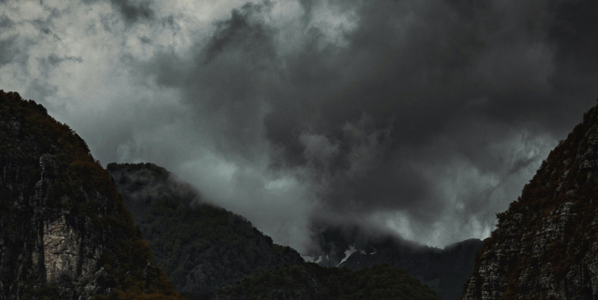
Accursed Mountains
From Albanian, “Bjeshkët e Nemuna”; Serbo-Croatian, “Prokletije” (Accursed Mountains), a range of high, jagged mountains, also known as the Albanian Alps.
The Accursed Mountain chain stretches from northern Albania through Kosovo and Montenegro, with the highest peaks reaching more than 8,800 feet. The steep karst limestone topography features sharp crags, vertical rock faces, precipitous cliffs, caves, tremendous waterfalls, ice-clad pinnacles, and avalanches. Some deep valleys and yawning canyons descend more than 3,000 feet. The rugged, zigzagging massif is the result of the collision of the African and Eurasian tectonic plates about 100 million years ago and later massive glacial activity in the Pleistocene epoch. Surprisingly, several glaciers are hidden in the mountains (four were only just discovered in 2010), along with numerous relict arctic plants from the last ice age. Vegetation is exceedingly rich, with more than 2,000 species of wild plants, including more than 100 medicinal herbs. Many animals long extinct in most of Europe still dwell in the Accursed Mountains: wolves, brown bears, otters, wildcats, lynxes, chamois, eagles, a newly discovered lizard, and venomous vipers. The last true wilderness of Europe, the inhospitable Accursed Mountains have never been fully explored.
Some of the valleys have been inhabited since the Stone Age, and some tiny villages trace their history back to the Middle Ages. In classical antiquity, the mountainous region was notorious for bandits; in modern times, blood feuds among clans were rife. Early travelers remarked on the fairy-tale character of rustic stone villages and the awe-inspiring beauty of the Accursed Mountains. Of course, the high pastures and winding paths in the peaks were long known to local shepherds and villagers. Many of the old stories feature vilas, nymphs or fairies of the forests and mountains. It was said that vilas especially loved to bathe in the medicinal waters of the high glacial lake Hridsko Jezero (Crag Lake) also called Liqeni i Zanave (Fairy Lake), hidden under steep cliffs at 6,400 feet.
Several stories account for the ominous name of the stark, forbidding mountains. According to one tale, the devil escaped from hell and formed the jagged peaks in one day’s work. A Serbo-Croatian folktale tells how three handsome brothers went hunting deep in the mountains to provide food after their father died. One day they came upon a vila, a lovely fairy. Enchanted by her beauty, the brothers fought violently among themselves over her. Tragically, all three brothers ended up dead. Their worried mother searched the mountains until she found her sons’ bodies on a hill. She buried them there. The vila sadly explained to her what had happened. But the anguished mother cursed the fairy for the loss of her sons, and her wails of despair echoed from mountaintop to mountaintop.
Another legend relates that a woman and her children trekked into the mountains to escape enemies. In the blazing summer heat, they could find no water, and in despair the mother cursed the place. Some believe that the name originated with Slavic soldiers who once attempted to march over the trackless range into Albania. Others say the name arose because the Muslim Turks first invaded Albania by way of the mountains in the fourteenth century.
During the dictatorships after World War II, the natural barrier of the Accursed Mountains was fortified, set about with land mines, and patrolled, effectively isolating the stronghold of Albania from the rest of the world. The Accursed Mountains came to be called the “Forbidden Land.” However, once a paranoid hermit nation of Europe, after 1992 Albania began to emerge from its fortress mindset. During the breakup of Yugoslavia in 1992-98, violent ethnic and religious strife boiled over among Muslims, Orthodox Christians, and Catholics. Finally, in 2013, Albania joined with Montenegro and Kosovo to plan a peaceful cross-border 120-mile hiking trail called “Peaks of the Balkans.” Shepherds now guide and offer hospitality to travelers in the majestic and wild Accursed Mountains. Some route markers even transform the sinister name to “Blessed Mountains.”
Budj Bim
Pronounced judge jim, “high head,” in Dhauwurd Wurrung, the dialect of the Gunditjmara Aboriginal people; a dormant volcano in the Newer Volcanoes Province, southwest Victoria, southern Australia; also known as Mount Eccles.
In the Gunditjmara people’s “Dreamtime” story, the Great Creator dispatched four giant creator-helpers to form the land of Australia. Three of the giant beings went north and east. But Budj Bim remained in the ancestral homeland of the Gunditjmara people. There Budj Bim transformed into a violently erupting volcano, spitting liquid fire from between his tung att (teeth), while the trees and the land itself “danced.”
Today, Budj Bim stands as a cone 584 feet high, surrounded by other volcanic craters. The brow of the mountain represents Budj Bim’s forehead, the sharp basalt scoria rocks are the giant’s teeth, and the lava flows are his blood, which poured over the land. Budj Bim assigned the weeping she-oak (Casuarina) trees, whose whispering voices can be heard in the wind, to be the guardian spirits of the landscape. The tree’s hardwood is excellent for fuel, boomerangs, clubs, and shields. The lava flows created a fertile complex of wetlands, which supported the hunting, fishing, and eel-farming lifestyle of the Gunditjmara people for at least 40,000 years. By 6,600 years ago, they were living in lakeside settlements with houses made of basalt and wood. They engineered sophisticated eel and fish traps using basalt lava rocks. The complex of fishing traps makes up one of the earliest known aquaculture farming systems on Earth.
Scientific analysis by argon gas dating determines when molten rock solidified. The argon “clock” shows that Budj Bim erupted a little over 36,000 years ago. Archaeologists discovered a stone axe under the volcanic ash. The find confirms that tool-using humans could have witnessed the eruption from a safe distance; survivors recorded the event in the story told by the Gunditjmara people who have lived continuously in the region of Australia’s youngest volcanoes. This means that the oral legend about Budj Bim volcano may have been told and retold for more than 36,000 years. Scholars believe that Aboriginal tales conveying perceptive observations and understanding of natural evidence are some of the most ancient geomyths in the world, helping scientists to understand seismic, volcanic, and other geological events in Australia’s remote past.
Cameroon Death Lake
Lake Nyos in Cameroon, Central Africa; deadly carbon dioxide gas suddenly burst forth in 1986, creating a toxic cloud that killed nearly 1,800 people, 3,000 cattle, and countless domestic and wild animals, birds, amphibians, reptiles, and insects.
In Cameroon, there are two types of lakes. Good lakes have plenty of fish, have easy access for fishing and bathing, and provide water supplies. Bad lakes, believed to be inhabited by powerful spirits, are difficult to get to, have no fish, often change color, and are associated with death and destruction. Lake Nyos, an extremely deep lake in the volcanic highlands of northwest Cameroon, was in the second category. Notably, in the local Mmen language, nyos means “good,” a euphemistic way of appeasing the lake.
The round maar, or crater lake, covers only half a square mile, but it is 682 feet deep. It was formed just 400 years ago by a violent volcanic explosion of lava and water. The deep crater of the volcano now filled with water sits atop the still-active magma column of molten rock. This magma chamber beneath the lake charges the maar with millions of tons of carbon dioxide (CO2), which seeps up through fissures in the lake floor. The water of the deep lake is stratified, with a shallow layer of fresh rainwater occupying the upper 150 feet. As the columns of CO2 bubbles rise, they dissolve in the cold, deep layer of water under very high pressure, a continual process for centuries. But over time the water becomes supersaturated with CO2 and the lake becomes increasingly unstable, creating a hidden ticking time bomb should anything cause the deep, cold, densely saturated water to suddenly rush up to the warmer, low-pressure layer of the lake. Sooner or later, the upwelling water and escaping gas will produce a limnic eruption, the violent explosion of tons of carbon dioxide and water into the air. Picture shaking a bottle of carbonated champagne before popping the cork, but on a catastrophic, geological scale.
Cameroonian myths tell of lakes that suddenly shift location, rise, sink, or explode. Mindful of bad-spirited lakes, even though the soil near the lake is rich and fertile, the most long-standing ethnic groups in the area have always built their houses on high ground well away from Lake Nyos. In contrast, since the 1940s newcomers have settled around the shores and valleys near the lake.
One oral tradition about Lake Nyos describes how people long ago attempted to cross the dry lake bed between the high, contorted rock formations of the maar’s volcanic rim. Suddenly the waters surged back and everyone drowned. People say the voices of the drowned ghosts can be heard between two rocky crags. Could the story contain a collective memory of the original eruption of the volcano, only 400 years ago?
Details in geomyths can shed light on how and when great geological upheavals occurred around the globe, and how humans responded to them.
Another legend explains how in the distant past, the nefarious Lake Nyos was formed from the decomposing body of a Kom chief whose people had been tricked and murdered by the Bamessi tribe. To take revenge on the Bamessi and save his surviving people, the Kom chief decided to hang himself. The chief warned the Kom people not to disturb his body and not to try to fish in the lake that his bodily fluids would create. Instead, the Kom should wait until the lake formed and then, on the day the Bamessi traditionally set aside for fishing, the Kom should secretly move away to another land. On Fishing Day, the Bamessi went to the mysterious new lake to fish. Suddenly, the lake exploded, killing the Bamessi, whose bodies sank to the depths.
Anthropologist Eugenia Shanklin’s analysis of the details in this legend, and her discussions with Kom people (1989), led her to conclude that the geomyth arose after a real natural disaster centuries ago. She notes that lakes only form during heavy rains and that traditional Fishing Days fall in the rainy season, suggesting that the lake exploded during the rainy season. Cameroon is subject to very heavy rainfalls. Turbulence in Lake Nyos changes the color from clear blue to mud-brown or reddish from iron sediments.
In 1983, the prominent tribal leader in the Nyos region, known as the Lake Chief, died. Before his death, he expressed his last wish. Two versions of his request, recounted by tribesmen, differ slightly in the details. In one, he told his kinspeople to select his best, fattest cow to be given to the tribe’s secret Kwifon society for sacrifice. In the fuller version, he commanded them to drive his best, fattest cows over the sheer cliffs above Lake Nyos as a sacrifice to the spirit of the lake, Mami Wata, the goddess of life-giving and death-dealing waters. It is plausible that the Lake Chief knew the story of the exploding lake and hoped that sacrifices to Mami Wata might forestall another catastrophe. But the chief’s kinsmen failed to honor his request. Arguing among themselves, they decided to keep his best cow and sacrificed a skinny cow instead. No cows were driven over the cliff into the lake, but some recalled that a week after the Lake Chief’s death, his finest cows were seen walking in single file toward the lake.
It rained hard on August 21, 1986, the beginning of the rainy season. That evening, as people cooked meals and prepared for bed, something caused the entire lake to erupt, releasing a massive 1.6 million tons of CO2. An immense foaming fountain of gas and water shot 260 feet in the air. As the water cascaded down, it washed out cornfields and flattened banana and fig trees. Survivors only noticed a distant rumbling. An expanding cloud of deadly gas rose more than 300 feet above the lake and was silently propelled about 45 miles per hour down the populated valleys radiating from the lake, instantly suffocating nearly every living thing in its path as far as 15 miles away. In Nyos town, only four of the 1,200 inhabitants survived. Those few villagers who miraculously lived were rendered unconscious. They awoke the next morning to a horrific scene, surrounded by the corpses of family, friends, and livestock. People living at higher elevations escaped the toxic cloud. When they came down to the villages, they were shocked by the surreal sight and eerie silence of the unthinkable disaster. No houses were destroyed, nothing was burned, just silent death everywhere. There were no flies on the dead people and animals—even insects had succumbed to the invisible stealth killer. About 1,746 people died, along with thousands of cattle, sheep, goats, chickens, dogs, and untold birds, antelope, and other wildlife.
Among the survivors, many remembered the Lake Chief’s last wish and attributed the catastrophe to the wrath of his departed spirit. Some suspected a secret government weapons test, or a bomb planted in a plot to mine diamonds under the lake, while others heard tales of old witches turning into savannah buffalo and plunging into the lake. Scientists, for their part, were hard-pressed to pinpoint the cause of the disaster. They understood the dangerous stratification of the deep maar, the exponential feedback cycle of the plumes of CO2 bubbles, and the consequences of the sudden upwelling of cold CO2-laden water from the bottom layer to the top, where the pressure of the gas exceeds that of the water. But what caused the turbulence that suddenly reversed the layers? What triggered the massive quantities of gas-rich water to explode at the surface of Lake Nyos? Some propose seismic tremors sent waves that forced the deep water upward. Could strong winds perturb the layers? Perhaps there were explosions of steam from the volcano at the bottom? Some hypothesized that an underwater landslide displaced the deep water. This had happened at another maar about 50 miles away. Lake Monoun exploded and released carbon dioxide gas that killed 37 people on August 15, 1984, a year after the Lake Chief’s death. Scientists at Lake Monoun found evidence of a large landslide that had occurred the night before, stirring up the gas-rich bottom layer. But no evidence of a landslide was found at Lake Nyos.
Another theory is that very heavy rainfall after serious drought violently sloshed the waters of Lake Nyos. During drought and heat, much of the top layer of the lake evaporates, reducing the amount of water that served to seal the bubbling, gas-rich lower layer. The shallowness of the warm top layer would be vulnerable to mixing, as colder, heavy rain fell, driving the shallow water down and the deep water up. A driving rain indeed occurred on August 21. The Kom legend of the exploding lake during the rainy season comes to mind. Whatever the trigger was, to prevent recurrence of the calamity, degassing facilities were installed at Lakes Monoun and Nyos to remove the continual buildup of carbon dioxide gas.
__________________________________
From Mythopedia: A Brief Compendium of Natural History Lore by Adrienne Mayor. Copyright © 2025. Available from Princeton University Press.